
GSCD
Global Streamflow Characteristics Dataset
Overview
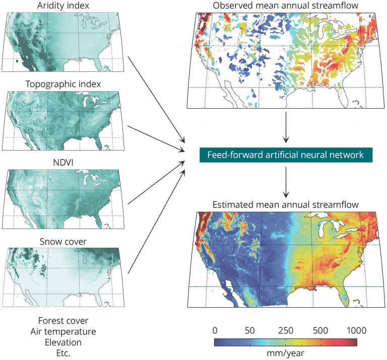
The Global Streamflow Characteristics Dataset (GSCD) consists of global maps of 17 streamflow characteristics, such as baseflow index, runoff coefficient, and flow percentiles, providing information about runoff behavior for the entire land surface including ungauged regions.
The maps are unique in that they were derived using a data-driven (top down) approach based on streamflow observations from thousands of catchments around the globe, as opposed to a physically-based (bottom up) process model. For more information, see the following open-access papers:
- Beck, H.E., A.I.J.M. van Dijk, A. de Roo (2015)Global maps of streamflow characteristics based on observations from several thousand catchmentsJournal of Hydrometeorology 16(4), 1478–1501
- Beck, H.E., A.I.J.M. van Dijk, D.G. Miralles, R.A.M. de Jeu, L.A. Bruijnzeel, T.R. McVicar, J. Schellekens (2013)Global patterns in baseflow index and recession based on streamflow observations from 3394 catchmentsWater Resources Research 49(12), 7843–7863
Download
The latest version of the GSCD (version 2.0) can be downloaded here (372 MB). See the technical documentation for the version history. The data are released under the CC BY-NC 4.0 license and thus may not be used for commercial purposes. If the dataset forms a key component of your research, we kindly ask that you give us the opportunity to comment on your results prior to publication. By using the GSCD in any publication you agree to cite the above-mentioned papers.
Acknowledgements
The following organizations are thanked for providing streamflow and/or catchment boundary data: the United States Geological Survey (USGS), the Global Runoff Data Centre (GRDC), the Brazilian Agencia Nacional de Aguas, EURO-FRIEND-Water, the European Commission Joint Research Centre (JRC), the Water Survey of Canada (WSC), the Australian Bureau of Meteorology (BoM), and the Chilean Center for Climate and Resilience Research (CR2, CONICYT/FONDAP/15110009).