
PBCOR
Precipitation Bias CORrection
Overview
- Beck, H. E., T. R. McVicar, M. Zambrano-Bigiarini, C. Alvarez-Garret, O. M. Baez-Villanueva, J. Sheffield, D. Karger, and E. F. Wood, 2020Bias correction of global high-resolution precipitation climatologies using streamflow observations from 9372 catchmentsJournal of Climate 33, 1299–1315, doi:10.1175/JCLI-D-19–0332.1

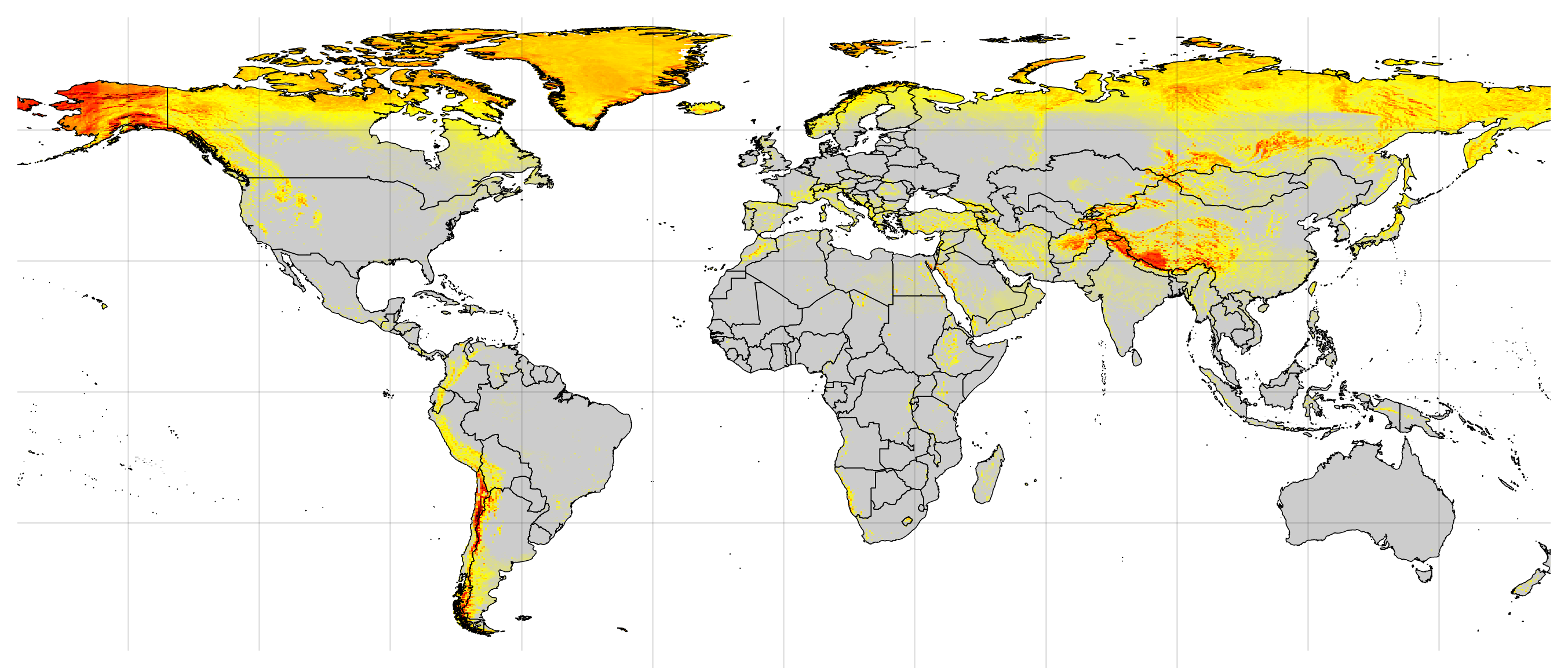
Bias correction factor
Download

Acknowledgements
Frequently asked questions
The three precipitation climatologies that we used as baseline (i) have a high resolution, (ii) incorporate a large number of gauge observations, and (iii) explicitly account for orographic effects. They can therefore be expected to provide more accurate climatological precipitation estimates than other datasets. Other datasets can be bias corrected by rescaling them to match one of the bias-corrected climatologies.
This is is not recommended as each version exhibits unique bias patterns. Note that the original uncorrected precipitation climatologies are also included in the dataset, in case they are no longer available via the developers’ website.
First, your gauge observations may underestimate precipitation due to gauge under-catch. Secondly, your (point scale) gauge observations may not be representative of 0.05° grid-cells if there is a high spatial variability in the region. Thirdly, the baseline climatologies may be wrong due to a lack of, or errors in, the gauge observations used to produce them. Finally, our bias corrections may be wrong, due to (i) errors in the streamflow, potential evaporation, or catchment boundary data; (ii) uncertainty in Fu’s (1981) w parameter used to infer precipitation from streamflow; and (iii) uncertainty in the random forest regression of the bias correction factors.
That depends on the region in question. In general, one can assume that the climatology that incorporates the largest number of gauge observations for a particular region is best. Maps of the gauge observations incorporated in each climatology can be found in the corresponding publications (Fick and Hijmans, 2017, Karger et al., 2017, and Funk et al., 2015).
The GPCP and GPCC climatologies (i) have a fairly coarse 0.5° spatial resolution and (ii) were corrected for gauge under-catch by interpolation of correction factors derived from sparse and unevenly distributed station networks. They may therefore underestimate precipitation over mountainous areas, as demonstrated in the PBCOR publication (Beck et al., 2019, Fig. 7).